Add a 2D Map or Floor Plan to Your 360 Image, 3D Model, or Virtual Tour
SeekBeak allows you to use flat 2D images, or 3D Models, as Maps to link your Snaps together! 2d Image maps are basically the equivalent of a Floor Plan, with more of a generic name to cater to the myriad of ways you all are using SeekBeak.
After more than a few attempts, we at SeekBeak HQ think we've come up with a nice balance of flexibility, and ease of use, with the new Maps feature.
Creating a Map, and using the new Map Editor, is almost identical to the way you've been adding Hotspots to your Snaps, just now in 2D. You have the same options for colors, icons, and animations as your Snap Hotspots do. Hotspot placement, editing, and adjusting is all the same as well!
I've done up a quick video that shows how simple the whole process is:
How Do the Maps Work?
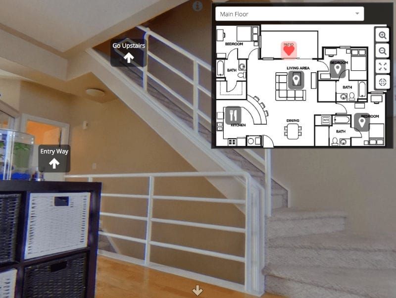
When you have a Map, or Maps, uploaded to a Group, anyone viewing a Snap within that Group will see a new "Maps" option in their bottom navigation bar. Clicking it will pop open the flashy new Map Viewer.
The Map Viewer comes with some cool options, like map selection, full screen view, zooming, dragging, and auto re-centering.
Did we mention that the map features work the same on mobile as they do on desktop, including ALL the editing and viewing functions?